Sunday, June 30, 2013

Taidnapam Park

Taidnapam Park is the park we are staying in for the next few days just outside of Glenoma, WA.  After five days of driving we decided to just kick back today and recoup a bit.  From the pictures below, you can see the park is beautiful.  We liked it so much we rearranged our trip to stay a couple of extra days here.  
This morning I just sat for several hours outside our camper, drinking coffee, reading a little, watching the birds, and even dozing a bit on and off.  It was wonderful.  It was just what was needed after several days of driving.  

Scenery within the campground

The Park's fishing pier

Day use area on Riffe Lake

Just to show that politics is alive and well in rural Washington, here is a picture of a fellow's house just outside Glenoma.

Saturday, June 29, 2013

Cascades


Continuing our trip to the great Northwest....   we departed Plymouth, WA, and made our way north west toward the little town of Glenoma, WA.  After some driving on interstates, we ended up on Hwy 12, and and as we entered the Cascades we came to a spectacular viewpoint.  It was our first glimpse of Mt. Rainier.  In the photo below, the mountain is cut off  by clouds, so you can't see it's rounded top.  We will be visiting Mt. Rainier National Park in a couple of days, and will have more information on this great mountain.


We reached Glenoma and set up camp in a campground alongside Riffe Lake.  We are going to relax here a day or so prior to visiting Mt. Rainier and Mt. Saint Helen National Parks.


Our campsite near Glenoma, WA

Friday, June 28, 2013

The Oregon Trail

                           
Actual covered wagon from the 1800s that made the trip

Today Kathy and I continued our NW RV trip by traveling from Twin Falls, ID, through Oregon, to Plymouth, Washington on the Columbia River.  Just outside Baker City, Oregon, we stopped for a picnic lunch at a BLM interpretive center providing information on the Emigrant Trail...  also known as the Oregon Trail.   From the middle 1800s,  and continuing on to near the end of the 1800s, several hundred thousand traveled by covered wagons, from Missouri to Western Oregon, virtually all following the Oregon Trail.

After spending an hour or so reading and learning of this part of American history, I now have a new appreciation of the Emigrant effort.  Any thoughts that might have entered my mind that the trailer pulling trip we are on, was a little bit similar to crossing the country in a covered wagon, were totally erased.  This was a tough 2000+ mile trip that took six months, and it looks to me that one would be lucky to make it through alive.  It would have been very lucky to make it through alive, with your family intact.

Here are just a few other pics from the day.


An amazing statement at the Emigrant Interpretive Ctr - on the Oregon Trail outside of Baker City, OR

If you zoom in you may be able to pick out the remains of the wagon tracks from long ago

Relaxing in Plymouth, WA on the Columbia River


Thursday, June 27, 2013

The Snake River


The Snake River Valley - Twin Falls, Idaho

After driving north on US93 all morning from Ely, NV, we landed in Twin Falls, Idaho on the Snake River.  We set up camp and then headed out to see some of the sights, and of course, to pick up a few geocaches.  

Near our campground we stopped at an overlook of the Snake River, and were surprised to see parks and golf course right down in the river valley.  Near this part of the river is where Evel Knievel attempted to jump the canyon back in 1974, riding a rocket propelled motorcycle.  The attempt failed when his parachutes opened early in mid flight. When I looked at the gorge, it was hard for me to believe anyone would even attempt such a thing.

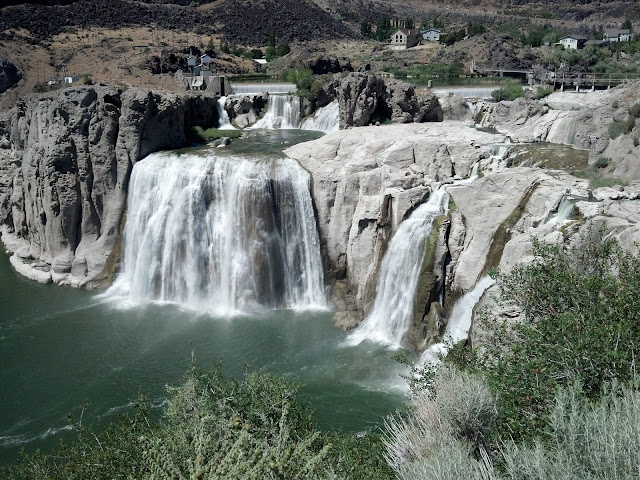
Next we visited Shoshone Falls, sometimes called the Niagra of the West.  This is a very beautiful recreation site, with picnic grounds and trails around the falls.  The site is now set up to capture hydroelectric power.  The thunder of the falls was memorable.  

Shoshone Falls - Twin Falls, Idaho

We then searched out a little park owned by the power company that hosts a couple of overlooks where you can view - The Twin Falls, the town's namesake.  We were surprised to find that what was once the Twin Falls (two falls), now is a single fall, although still called the Twin Falls.  The river was channeled to provide the most hydroelectric power, and as a result, the second fall no longer exists.  It used to flow over to the right of the now existing fall. 

The Twin Falls - Twin Falls, Idaho

After a bit of shopping for supplies, we investigated the historic downtown area of Twin Falls, and enjoyed a nice dinner, and some pretty good live music.  Some of the streets had been closed off downtown for the music event.  We noticed a lack of diversity in the crowd, but this may well have been due to the music being played...  largely country pop. 

Kathy and I enjoyed this town, and thought is was a very nice place to visit.   


 The downtown crowd listening to live country music - Twin Falls, Idaho

Wednesday, June 26, 2013

The Loneliest Road in America


Highway 50 runs through the middle of Nevada from East to West, crossing nine mountain ranges, and just a couple of small settlements.  In 1986, Life Magazine published an article stating that this stretch was the Loneliness Road in America.  The name stuck, and the state of Nevada capitalized on the article,  and soon it was a place for adventurers, world travelers, and the like.

Even with the state's efforts, this highway is still pretty lonely.  Kathy and I traveled just a piece of it on the eastern side of the state late today, and stopped for the night in the little town of Ely, NV.  There, we enjoyed the cooler temperatures, beautiful blue skies, and fluffy white clouds.  We did a little geocaching and found 4 caches, which was fun.  But mostly we relaxed.

Before reaching Hwy 50, we drove the beautiful scenic US Highway 93 up from the Las Vegas area.  We stopped for lunch in the cute little town of Caliente, NV.  There we enjoyed a local park, and peanut butter sandwiches.  What's not to like?

Here are a few pictures from our travels today.....

Old Union Pacific Railroad station in Caliente, NV


Lunch stop, Caliente, NV


Highway 50, the Loneliest Road

Kathy enjoying the shade from Cottonwood trees - Ely, NV

Angie enjoying the shade from Cottonwood trees - Ely, NV

The Steptoe Valley, near Ely, NV


Tuesday, June 25, 2013

Highway diverted

Lake Mead as seen from our campsite

As we drove the last miles on the first day of our NW trip, we fully expected to cross over the Colorado by driving  over the top of the Hoover dam as we had years ago.  Well, somehow we missed the dam altogether. We traveled on and made our way to our first RV park of the trip, situated on the western side of Lake Mead.  Not seeing the dam totally confused us.  How could you miss the Hover dam.  Not a small or trivial item.

So, after we got our campsite set up, we took the car and drove out to look for the dam.  It had to be somewhere.  After following a maze of signs, we finally came to the western entrance of the road that goes over the Hoover dam.

Soon we found ourselves being questioned at a security check point, by guys with guns.  I asked these fellows what happened to the original highway that went over the dam, and their single answer was... "9-11."  It turns out after the September 11 attacks, a new bridge was built to divert the highway traffic away from the dam for security reasons.  This is why we missed the dam on the highway.  It was a different highway.

Well, the old road over the dam is now used as a kind of tourist location.  You have to go through a check point to drive over it, and the road doesn't go all the way through to the main highway anymore.  After you drive over the dam, your only option is to turn around at a closed road sign, and return all the way back over the dam, and through the same check point again.  Still, there is ample parking on the eastern side of the dam, and they allow you to walk back across after parking your car to take pictures, tours etc.  

The sight never fails to amaze me.  It is large, on an Egyptian pyramid scale.  Here are a few views from the top of the dam.


Mike O'Callaghan–Pat Tillman Memorial Bridge - building began 2005, completed in 2010


Kathy in front of statues honoring builders of the dam

The spillway and Lake Mead side of dam

Outflow on back side of dam.  Note cars and trucks for perspective.

Monday, June 24, 2013

Miracle and Wonder


Well, we are all packed and just now heading out on a 30 day RV trip to the Northwest area of the country.

Yesterday, as I was finishing packing, I found myself calling a number of people all across the country to say good by.  As I think of it now, these calls were strange. Not strange to talk with the folks.  That was great. Strange because we can now call from anywhere, virtually anytime, with no additional cost on our phone bill.  We can email anyone from anywhere.  We can even video chat at a moment's notice.  So why did I feel I should call folks before our trip?  Even stranger, why haven't I called these folks on a more regular basis before?  It is just a phone call.  It is within my ability to chat with anyone, anywhere, anytime from a device I carry with me all the time,  right in my pocket.  Yet....  I rarely do this.  Weird.

Well, it is not just me.  We all have this ability these days.  Cell phones, tablets, PCs, Skype, text messaging...  We all can do it.  We can all talk often to all our friends regardless of boundaries, but other than regular family calling, how often do we use this technology with distant friends?

I am going to try to drop a call to friends far away, more often.  If they were here, visiting, in town, I would be going out of my way to see them to catch up.  Well, we can all "catch up" anytime.  Let's take some action following that parting statement we all make...  "Stay in touch."

Paul Simon has a nice line in one of his songs.... 

"These are the days of miracle and wonder.  This is the long distance call."  

I'm all for miracles.  Let's grab one.  Call a friend you haven't talked to in a while.  :-)

Sunday, June 23, 2013

Clouds. Wow!


I know it will sound ridiculous to our friends and family in the East, but after many weeks of nothing but clear blue skies, having a cloud to look at is something special.  One of our friends, Jim S, here in the community made a statement the other day that highlights the desire for clouds.

    "There was a sighting today," he said.
    "What?" I asked.
    "A cloud was seen," he explained.

Southern Arizona receives not one, but two rainy seasons annually.  The first is during the winter months of January through mid-March, and it shows itself as light soaking rains, and occasional small amounts of snow in our community. These winter storms stream across from the West coast. The second rainy season of the year for Arizona, and Tucson in particular, occurs from July through mid September.  This period is called the "monsoons" by weather professionals as well as the general public.  During this time, moisture from the Gulf of California streams north, allowing for some pretty spectacular and violent afternoon thunderstorms.

Because of the two rainy seasons our area receives annually, our desert (the Sonoran Desert) is much more lush compared to the other three major desert regions of the country, which only receive one annual rainy season each.

Major Deserts of North America


A monsoon thunderstorm


 The clouds we are seeing this morning are the early beginnings of the monsoon period. Although no rain is in the forecast yet, it is always notable here to witness a "sighting".    :-)


Saturday, June 22, 2013

Open Mind

Photo by Don Nores


Once in a while I run across something that makes me think long and hard.  (scary)  When this happens, I seem to keep coming back to the item again and again.

A while back, I was reading a book describing the teachings of the Buddah.  Don't worry, I am not going to go into all of that with you, but there was one really striking passage that made me take pause.  It simply said:


"Usually when we read or hear something new, we just compare it to our own ideas.  If it is the same, we accept it and say that it is correct.  If it is not, we say that it is incorrect.  In either case, we learn nothing.  But if we read or listen with an open mind, this can be different..."

I began thinking how often I compare what I read, hear or see to my personal beliefs, background and experiences, and just how quickly I make a judgement call.  Often, the experience is over just that quick for me.  I shut it out as being wrong, or just overlook it as an "of course" situation if I think it is right, and move on to my next thought.  I wondered what I might be missing by this practice.  I know that I often, at least mentally, cut off a person expressing a new idea, because I have already jumped to judgement.  Wow, I have probably missed a lot over the years....  I have some catching up to do. Of course judgments must be made to exist in the world, but I am now working on letting the new ideas play out a while longer before I pass judgement.  I am still not very good at this, but I'm working on it.

I found it interesting to think of these things, and thought you might find it interesting too.

Friday, June 21, 2013

Game Ride anyone?


Kathy and I own a golf cart, but don't play golf.  (at least not yet)  So why have the cart?

All the roads in our community are private, and it is permissible to ride a golf cart around on the streets to clubs, pickleball courts, friend's houses, etc.  But the real selling point for us when we were thinking about getting a cart was the prospect of taking "Game Rides."

Our community has a good selection of wildlife to view if you get the chance.  Our friends Bart and Karen C. told us about the fun of driving the golf courses (we have three full courses in the community) just before sundown to look for wildlife.  Rabbits, javelina, deer, coyote, rattle snakes, and bobcats are often seen.  If you were really lucky you might even sight a bear or mountain lion although these are rare in our area.

There is no one better to sight animals in the wild (that I know of) than Bart.  Bart and Karen led the way last night on a game ride.  Following in our cart, we all had a great time prior to being shut down by darkness.  Here are a few examples of what we saw on this trip.....

Rabbits, and more rabbits.  Rabbits everywhere.  The bottom of the food chain.

They blend in well don't they..

An unexpected sighting....

Deer, waiting to tee off.  This course is crowded sometimes...

Ever since I was a kid and saw the movie Hatari back in 1962, I have wanted to go on a game ride.  :-)
Just to bring back memories...  try this 3min YouTube video....     Click HERE.   Enjoy.

Thursday, June 20, 2013

Sasco, and the towns of Silverbell and Silver Bell

Ruins of Sasco's Rockland Hotel

A couple of months ago, friend and photographer Ron T and I did some exploring just west of Red Rock Arizona, hoping to find what was left of several old ghost towns.

The first found was the remains of Sasco, an acronym for the Southern Arizona Smelting Company.  It had been built in 1907 and was the smelter town for mines at Silverbell and nearby Picacho Peak.  It had once been a community of 600 and featured a smelter, residences, saloons, stores, a jail, and the Hotel Rockland.  A post office served the community until 1919.  Ron and I explored what remained, including an old fenced graveyard.

Old postcard of Sasco


Ron, walking the Sasco townsite


Smelter Ruins - Sasco 


At Sasco


 Ron at Sasco


At Sasco


Sasco Cemetery

After walking around Sasco for a good while, we continued down the dirt road for 12 miles looking for the old town of Silverbell.  A lot of this route was on the right-of-way of the Arizona Southern Railroad built in 1904 to carry ore from the mills at Silverbell to the smelter at Sasco.  The tracks were taken up in 1934.

The site where the town of Silverbell stood was now nothing but shallow valleys and hills.  There was nothing left to see.  Silverbell had once been a town with a  population estimated at 3,000, and had existed between 1860s and the 1920s. The town's boom was between 1902 and 1911. A post office was established in 1904, and a Wells Fargo station opened in 1906.  Copper was the focus of mining there, but in 1911 a shaft fire combined with financial  problems led to bankruptcy for the company that owned the mine.

All that Ron and I could find was the unprotected Silverbell cemetery.  This was a sad site indeed, as much of the graves were decaying back into the desert.  Few graves were marked, and it occurred to me that this place might completely disappear in the next few years.

Silverbell Cemetery


Ron, replacing a fallen cross - Silverbell cemetery

Silverbell cemetery


One of only a couple of graves marked with a name at the Silverbell cemetery

Continuing down the old road, we came near where we think the town of Silver Bell (two words) once stood.  It was a town from 1948 into the 1980s.  It turns out the road to Silver Bell had been rerouted south, and what was left of the town's buildings had largely been removed. The townsite is now covered over by massive tailings from the current Silverbell copper mine at the end of Avra Valley Road.  

It took me a while to sort out the difference between the town of Silverbell, the town of Silver Bell, and the current Silverbell mine, but I think I have it now.  Ron and I had a fun trip that day, and we learned a little of the local history.  We found a few geocaches too, which was a plus.  But mainly we found that towns come and go, lives come and go, and all legacy is fleeting.