Monday, July 8, 2013

"Ocian in view, O! the joy..."

The Pacific

On November 15, 1805, the Corps of Discovery, led by Captain Meriwether Lewis and Captain William Clark, finally reached the Pacific Ocean. This, after a tremendous amount of aid and comfort afforded them by the existing residents along the way.  "Ocian in view, O! the joy..." were the words Clark put in his journal on November 7.  He was actually at a Columbia River Estuary.  It was over a week more of travel before they reached the coast.  The group went on to build a tiny fort just off the Columbia River and up a little feeder river, (now called the Lewis and Clark River).  The fort was called Fort Clatsop, named after the local resident group of people already living there.  Again, with the help of the locals, they made it through the winter. In the Spring of 1806, after no trading ships arrived that might have given them passage back East, they headed out again to travel by land back to Missouri.

Today, all over the Astoria area,  on both sides of the Columbia River, there are National and State Historical parks, National Historical Register items, and multiple other references to Lewis and Clark and their group.  We are even staying at the Lewis and Clark RV Resort, as an example.

Today was a busy day.  We took in a lot of sights.  We hit the replica of Fort Clatsop, visited the Astoria Column, walked the Astoria town riverfront, and  drove out  to Cape Disappointment and the Lewis and Clark Interpretive Center.  There we too got a good clear afternoon view of the Pacific.  Then we headed back to our camper to feed Angie, and later went for more oysters.  We couldn't resist.

It was a nice day.  All the information about L&C became overpowering for me.  The Corps of Discovery, clearly were travelers through cities and towns much like Kathy and I are doing on this trip.  I am aware that for Europeans at that time, this was much like a trip to the moon.  It was uncharted.  Even President Jefferson expected the group to possibly find dinosaurs and mastodons.  But it is clear, by what I read today, that the area was not uncharted really.  It was fully inhabited, and reasonably civilized, even by European standards, as if that matters.  But that is not what they taught me when I went to school.  Anyway....

At a couple of the L&C interpretive centers, I tried to have some fun by quietly mentioning to interpreters that I am in fact, a very distant cousin of Meriwether Lewis (something my brother uncovered in his genealogy research). They uniformly seemed politely unimpressed.  :-)

Astoria

Astoria is named for John Jacob Astor, a business man from New York, who specialized in the fur trade and moved to have "occupied" the area around  the mouth of the Columbia, just several years after the L&C arrival.  He was successful, and he became very wealthy doing so, as well as through other ventures.  Who would have thought there would have been such demand for animal fur?  I don't think that business plan would work in these times.  His family continued to prosper, and still does to this day.  John's grandson was the famous Astor that went down with the Titanic (supposedly the richest man on the boat).  That Astor who was lost at sea was the father of the Astor that funded (with the help of the Great Northern Railroad) the building of the Astoria Column in 1926.  Nice place to sail a little balsa wood glider off of.

We liked Astoria, Warrenton, and the neighboring Washington State town of Ilwaco.  Here are some  photos we took today.

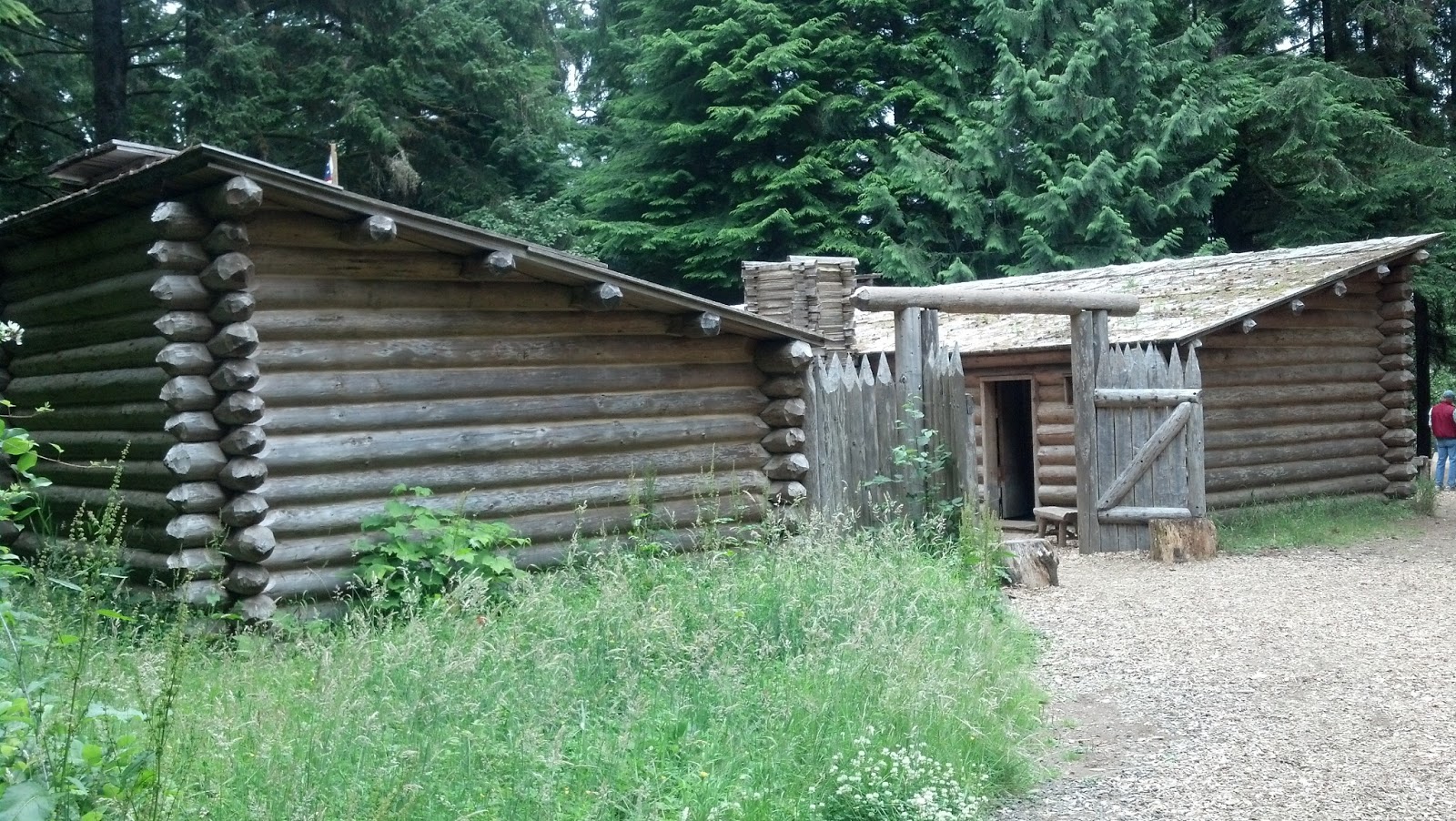
Replica of Fort Clatsop on the actual site

Statue representing Sacagawea

The Astoria Column that we climbed to the top of...   164 steps.  Whew...

Young ladies at the top of the column waiting to send their gliders off for a ride

Along Astoria's waterfront

Lunch stop - at Fort George Brewery and Public House

Chalkboard Art at the Brewery

Flowers in an Astoria garden

View from Cape Disappointment

View from Cape Disappointment


Sunday, July 7, 2013

Reaching Astoria


It was a long ride today along US Hwy 101, from just outside Port Angeles, WA, heading south all the way down to Astoria, OR on the mouth of the Columbia River.  Along the way, we traveled beside the Pacific ocean, and stopped at several beaches.  We had expected to spend some time walking along the rocks and the surf, but the weather was not cooperating.  It was foggy, then cloudy, and a bit cold all day.  After arriving in Astoria, we did enjoy a wonderful seafood dinner at a local establishment recommended by our RV park manager.  This was the day's highlight for me...   Fried Oysters. Yum.    :-)

After dinner, we found and logged our first geocache in Oregon.  Along with our finds in Victoria, this gives us 5 new states, and one new country for our geocaching statistics so far this year.


Saturday, July 6, 2013

Victoria, Sweet Victoria


Today, Kathy and I took the ferry from Port Angeles, Washington, to Victoria, British Columbia.  It was a beautiful 1.5 hr trip across the Strait of Juan De Fuca, landing in the capital of British Columbia.  Our mission was to find at least one geocache, the first we would record in Canada, and to look around a bit.  Well, right off we worked on geocaching.  We quickly found the first, but went on to find four more.  The hunt, as it often does, took us to some of the not so well traveled areas of the town.  We got to visit a community garden, a local farmer's market, the grounds of St. Ann's Academy, as well as the back garden of the Parliament building.  We enjoyed the walk around the back roads, and away from the more common tourist areas.  After a nice lunch, we strolled along the waterfront.  In the mid afternoon, we traveled back by ferry to Port Angeles.  Our pup, Angie, was waiting patiently for our return back at the camper.  

This short trip to Canada was a lot of fun. Here are a few random pictures from Victoria.  


Kathy and I traveled to Victoria today, which as I think of it, is our norm.  The traveling that is.  Yesterday was our anniversary, and during the 41 years we have been together, we have traveled a lot.  We have driven from coast to coast 5 times, visited Canada and Mexico multiple times, traveled to Alaska, as well as trips to England, Wales, Scotland, Jamaica, and Costa Rica.  I can't count the times we have traveled by air back and  forth across the country.  Since being married, we have lived in 9 different cities, and have occupied 20 different houses.  It seems travel is what we do.  I think we make a good pair for travel, exploring, and adventure, and we plan to continue our adventures for as long as possible.  There would be no better travel partner for me than Kathy.  It has been a great 41 years.  By the way, we are traveling tomorrow to Astoria, Oregon.  There we go again...  :-)

One last photo from Victoria.  While walking down a side street, we passed this government office that brought back memories of various positions I have held throughout my working career.  The position seems to be named and official in Victoria.  :-)


Friday, July 5, 2013

Forests of Rain

The Hoh Rain Forest is what I thought all of the Olympic National Park was like.  Instead, it is a unique area of this large park.  Being on the western side of the Olympic mountains, it is not in the mountain rain shadow.  It gets the full amount of Pacific moisture, and that's a lot.

Having lived in Juneau, Alaska I thought I knew all about areas with high precipitation.  Well, the Hoh Rain Forest area gets over twice the annual precipitation comparatively.  This comes in at just under 12 ft annually.  Juneau is considered a northern rain forest, whereas the Hoh is considered a temperate rain forest.  The result seems to be much larger trees, even more ferns, moss, and broad leaf plants at Hoh. 

One of things we learned that we thought interesting is that baby spruce, firs, and hemlock have a hard time getting a start on the choked forest floor.  Where they seem to get a foothold is on the top of decaying giant older trees that have been blown over in winter storms.  As their roots extend to the ground they begin to take off.  This process creates trees that are growing in a row for up to three hundred feet, the length of the old fallen tree.  These rows of trees are called colonnades.  I tried to get some pictures of various stages of this process.  Also, tried to take some other representative photos as well.  A beautiful,  if not a little creepy, area for sure.


From our camp, as we traveled to the Hoh Rain Forest area of the park, we passed by beautiful Lake Crescent, and a little town called Forks.  Forks is known as the setting for the popular Twilight saga, a series of five romance fantasy books/films that have something to do with vampires.  The town has totally capitalized on this, with tours, special Twilight rooms at the local motel, and even a subway sandwich named the Twilight.  I have not read any of these, or know much at all about them, but it seems to be popular here.  By the way, we were told the films were not filmed here, but the books were set here.  I guess that was enough.


Thursday, July 4, 2013

Hurricane Ridge


After a nice breakfast at a local restaurant along US Hwy 101, and a couple of cell calls from our family and friends, Kathy and I headed up a 15 mile winding road in the north central part of the Olympic National Park.  We traveled through a layer of clouds, saw blacktail deer, and saw a lot of visitors.  As we broke through the cloud bank, we arrived at sunny and clear Hurricane Ridge.  Wow!  The views were drop dead gorgeous.  My brother-and-law, Richard H, advised us not to miss this area of the park, and he was spot on.

On this ridge, atop one of the numerous lower mountains within the park, you get full view of the Olympics, including Mount Olympus, the highest at 7,980 ft..  Tectonic plates, riding up over one another, pushed up these medium height mountains 10 to 20 million years ago (so very young mountains indeed).  The end of the winding road provided a visitor center, a few trails (all snow packed and impassable), and glorious views.  We had lunch there, but it was hard to chew with our mouthes closed in front of such views.  Trying to capture this in photos is difficult, but here are a few to take a look at.


As I am writing this post back at our camp, a couple of planes are outside doing loops and free falls as part of today's local celebrations.  We will spend the evening of the fourth at our camp...  enjoying a home cooked dinner and a bottle of wine....  or two.  :-)..  and listening to fireworks echo through the mountains here.  Happy 4th everyone.


Wednesday, July 3, 2013

Mt. St. Helen

On May 18, 1980, at 8:32am, Mt. St. Helens changed it's complexion in a big way.  With a blast 20,000 times greater than that of the Hiroshima bomb, an entire side of the mountain slid down in the greatest landslide in recorded history.  The interior lava was then exposed to lower pressure, creating a magnificent explosion upward, and sending pyroclastic flows of hot gas and ash traveling down the mountain in excess of 600 mph, leveling everything in its path for miles outward.  The ash fall fell over seven states.  Giant mud slides called lahars rushed downward also, realigning the landscape as they went.  57 people died that morning, along with almost all wildlife within the blast zone which stretched many miles from the crater.  200 houses, 27 bridges, 15 miles of railways, and 185 miles of highways were erased.  The whole devastation was over in less than 10 minutes.  I am glad I wasn't there to see it.


I was uneasy being there 33 years after the blast.  My uneasiness increased when I learned the mountain has continued to have minor eruptions since the big blast of 1980.  The most recent eruption to date was in 2008.  This was too close for my comfort.  Worse still, the volunteer asked me to train my binoculars on the lava dome in the crater, where I would see steam rising.  I indeed saw it.  Unsettling.

Much is made of the rebirth after the blast, and there is a lot of new growth.  Kathy and I enjoyed the wild flowers and the new trees, (largely replanted by a local paper company).  In general, my overall take on the visit was awe at the power of nature to destroy, and then to rebuild.  Here are a few pictures from our visit....


Tuesday, July 2, 2013

Rainier

It is difficult to describe in words.  Like the Grand Canyon, it is difficult to capture in a photograph.  All I can say is...  it is big.  It takes my breath away when I look at it.

Mt. Rainier, at 14,410 ft is the tallest mountain in the state of Washington, the fifth tallest in the contiguous states, but what really makes it seem so big is that it is a full 11,000 ft straight up from its base.  Snow capped and hosting 25 separate glaciers it is truly an amazing sight. 
We drove up to the visitor centers through dark stands of old growth Douglas fir, western red cedar and western hemlock.  We passed numerous waterfalls.  At the Paradise visitor center the snow was just melting from the parking areas on July 1st.  None of the trails from the center were open yet due to snow cover, except a single trail to the top, apparently only taken by mountaineer, ice climbing types. 

As an active volcano, Rainier, like Mt. St. Helens and other Cascade volcanoes has the potential to erupt again.  This is a fact that gave me some pause as I thought about it.  The scientists expect the mountain to give ample warning prior to entering another eruptive period, but the threat of unexpected mud-flows and glacier generated floods exists today.  I know a few scientists, and although they are brighter than I am, I still found myself looking over my shoulder from time to time.

Kathy and I really enjoyed our day in Mt. Rainier National Park, and I won't soon forget the beauty of this spectacular mountain.

Here are a few pics from the park.


Monday, July 1, 2013

A moment of silence

Kathy and I were saddened to hear of the 19 fallen firefighters who perished yesterday near Prescott, AZ.  We learned of this today while inquiring as to why the flag was at half mast at the Paradise Visitor Ctr in Mt. Rainier National Park.  A moment is warranted.